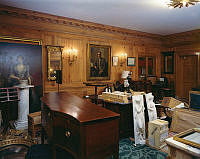
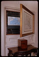
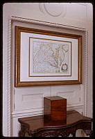
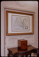
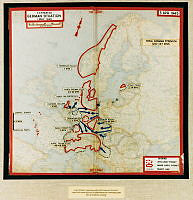
• Temporary Curator's Office in the Map Room
    Robert L. Knudsen
    Map Room
    Ground Floor
    construction & maintenance
    This photograph of the Map Room was taken by Robert L. Knudsen on May 10,1962, during the John F. Kennedy administration. The room is seen here with pieces from the White House Collection acquired during First Lady Jacqueline Kennedy’s White House restoration project. The room served as the temporary location of the curator’s office, where new acquisitions were examined and cataloged before being displayed in rooms restored during the project. The Map Room is located on the Ground Floor of the Executive Mansion and got its name during the Franklin D. Roosevelt administration when President Roosevelt used the room to monitor and intake classified information during World War II. The room was the original Situation Room. Today the room acts as a sitting room but still displays maps in homage to its origins.
  • Map Room and Map Case, Nixon Administration
    Joseph H. Bailey
    Larry D. Kinney
    Map Room
    Ground Floor
    This photograph was taken in the Map Room on August 1973 during the administration of President Richard M. Nixon. A framed 1755 map of Maryland and Virginia by Joshua Fry and Peter Jefferson, father of President Thomas Jefferson, is ajar to reveal a hidden map case behind it. The Map Room is located on the Ground Floor of the Executive Mansion and got its name during the Franklin D. Roosevelt administration, when the space was used to monitor and intake classified information during World War II as a predecessor to the Situation Room. In 1970, First Lady Pat Nixon worked with curator Clement E. Conger to transform the Map Room from an office space to a sitting parlor, with maps adorning its wall in homage to its former use.
  • Map Room and Map Case, Nixon Administration
    Joseph H. Bailey
    Larry D. Kinney
    Map Room
    Ground Floor
    This photograph was taken in the Map Room on August 1973 during the administration of President Richard M. Nixon. The hanging is a 1755 map of Maryland and Virginia created by Joshua Fry and Peter Jefferson, father of President Thomas Jefferson. Behind the hanging wall map, a map case is concealed. The Map Room is located on the Ground Floor of the Executive Mansion and got its name during the Franklin D. Roosevelt administration, when the space was used to monitor and intake classified information during World War II as a predecessor to the Situation Room. In 1970, First Lady Pat Nixon worked with curator Clement E. Conger to transform the Map Room from an office space to a sitting parlor, with maps adorning its wall in homage to its former use.
  • Map Room and Map Case, Nixon Administration
    Joseph H. Bailey
    Larry D. Kinney
    Map Room
    Ground Floor
    This photograph was taken in the Map Room on August 1973 during the administration of President Richard M. Nixon. A framed 1755 map of Maryland and Virginia by Joshua Fry and Peter Jefferson, father of President Thomas Jefferson, is ajar to reveal a hidden map case behind it. The Map Room is located on the Ground Floor of the Executive Mansion and got its name during the Franklin D. Roosevelt administration, when the space was used to monitor and intake classified information during World War II as a predecessor to the Situation Room. In 1970, First Lady Pat Nixon worked with curator Clement E. Conger to transform the Map Room from an office space to a sitting parlor, with maps adorning its wall in homage to its former use.
  • Map Room and Map Case, Nixon Administration
    Joseph H. Bailey
    Larry D. Kinney
    Map Room
    Ground Floor
    This photograph was taken in the Map Room on August 1973 during the administration of President Richard M. Nixon. A framed 1755 map of Maryland and Virginia by Joshua Fry and Peter Jefferson, father of President Thomas Jefferson, is ajar to reveal a hidden map case behind it. The Map Room is located on the Ground Floor of the Executive Mansion and got its name during the Franklin D. Roosevelt administration, when the space was used to monitor and intake classified information during World War II as a predecessor to the Situation Room. In 1970, First Lady Pat Nixon worked with curator Clement E. Conger to transform the Map Room from an office space to a sitting parlor, with maps adorning its wall in homage to its former use.
  • Map Room
    Erik Kvalsvik
    Map Room
    Ground Floor
    This undated photograph of the Map Room was taken by Erik Kvalsvik. The Map Room is located on the Ground Floor of the Executive Mansion and got its name during the Franklin D. Roosevelt administration, when President Roosevelt used the room to monitor and intake classified information during World War II. The room was the original Situation Room. Today the room acts as a sitting room but still displays maps in homage to its origins, as seen in this photograph of the southwest corner of the room.
  • Last World War II Situation Map
    Unknown
    Map
    This map was created in 1945 during the Franklin D. Roosevelt administration. The framed war map of Europe shows the movement of forces predicted for May 1, 1945 and was delivered to President Roosevelt during his respite in Warm Springs, Georgia in April 1945. It is likely the last map Roosevelt examined before his death on April 12th. The map was saved by Ensign George Elsey who worked in the Map Room, a room started by Roosevelt on the Ground Floor of the Executive Mansion to monitor movements and classified information during World War II. Today, the room is a sitting room, but the Map Room was a predecessor for the Situation Room.
  • Map Room, Barack Obama Administration
    Peter Vitale
    Map Room
    Ground Floor
    This photograph of the Map Room by Peter Vitale was 2010 during the Barack Obama administration. The Map Room is located on the Ground Floor of the Executive Mansion and got its name during the Franklin D. Roosevelt administration, when President Roosevelt used the room to monitor and intake classified information during World War II. The room was the original Situation Room. Today the room acts as a sitting room but still displays maps in homage to its origins, as seen in this photograph of the southwest corner of the room.
  • Map Room, Barack Obama Administration
    Bruce White
    Map Room
    Ground Floor
    This photograph of the Map Room by Bruce White was taken in 2010 during the Barack Obama administration. The Map Room is located on the Ground Floor of the Executive Mansion and got its name when Franklin D. Roosevelt used the room to monitor and intake classified information during World War II. The room was the original Situation Room. Today the room acts as a sitting room but still displays maps in homage to its origins, as seen in this photograph of the east wall of the room.