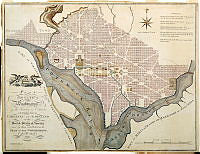
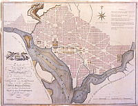
• Plan of the City of Washington
    William Rollinson
    drawings & plans
    This map showing the plan for the city of Washington, D.C. was published by John Reid (also referred to as I. Reid) around 1795, during George Washington's presidency. Though President Washington asked French-born architect Pierre Charles L'Enfant to design the new capital, L'Enfant clashed with many important stakeholders, including Thomas Jefferson, and eventually resigned his position. City planners consequently implemented the plan of surveyor Andrew Ellicott, depicted in this map. Ellicott's design very closely mirrored that of his predecessor, but L'Enfant did not receive any credit or payment for his contribution. Renewed interest in beautifying the nation's capital in the early 20th century, however, led to the revitalization of L'Enfant's vision, especially his plan for a "public walk," which became the National Mall.
  • The President's House
    Augustus Kollner
    White House
    north view
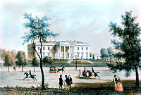
    This lithograph of the White House by Augustus Kollner was based on a watercolor painting. The view is of the White House from Pennsylvania Avenue and it was done during James K. Polk's presidency (1845-1849).
  • Scars from the Fire of 1814 on Stonework
    Erik Kvalsvik
    White House
    east view
    renovation
    War of 1812
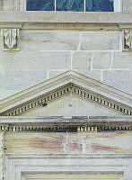
    This photograph of burn marks on the White House stonework was taken by Erik Kvalsvik in 1990, during the George H. W. Bush administration. Following a two year report, the White House underwent a renovation that included the removal of approximately 30 layers of paint and took place over 25 years, from 1980 to 1996. This process revealed scarring beneath the paint, sustained when the British burned the White House during the War of 1812.
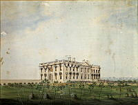
  • The President's House
    George Munger
    North View
    This watercolor by artist George Munger depicts the burned-out shell of the White after it was destroyed by British troops on August 24, 1814. The painting shows the once elegant and imposing house standing alone in the landscape, a vivid reminder of the destruction and that the capital city was still in its infancy. A curious element of the work is the S-curved shape above the near corner of the roof. It is believed to be part of metallic conductor that encircled the roof that functioned as lighting protection system.
  • 1800 Map of L'Enfant Plan for Washington, D.C.
    John Reid
    map
    This map showing the plan for the city of Washington, D.C. was published by John Reid in 1800 and based upon the famous L'Enfant-Ellicott plan published by Thackara and Vallance in 1792. President George Washington asked French-born architect Pierre Charles L'Enfant to design the new capital. L'Enfant developed plans for the city, but his refusal to cooperate with the president’s commissioners led to his dismissal in February 1792. The Commissioners of the District of Columbia began implementation of the plan under the direction of surveyor Andrew Ellicott. Renewed interest in beautifying the nation's capital in the early 20th century, however, led to the revival of L'Enfant's vision, especially his plan for creating cardinal features in the city with the Capitol and White House connected by "by a grand avenue four hundred feet in breadth, and about a mile in length, bordered by gardens, ending in a slope from the houses on each side." This vista was the inspiration for McMillan Plan's park-like means of communication between the legislative and the executive branches which became the National Mall.