• Garden Tour Program, Carter Administration
    White House Calligraphy Office
    program
    South Grounds
    drawings & plans
    maps
    This is the unfolded internal page of a program created for a public White House gardens and grounds tour during the administration of President Jimmy Carter (1977-1981). The program includes a greeting from First Lady Rosalynn Carter, a map of the South Grounds including sites of presidential tree plantings, and information about the history of the gardens and their uses. Before the late-19th century, private citizens wandered the White House South Grounds like a public park, but by the Calvin Coolidge administration (1923-1929), the grounds were closed to the public due to security and privacy concerns. However, just as First Lady Jacqueline Kennedy opened the White House to the public with controlled public tours, in 1972 First Lady Pat Nixon established the tradition of hosting White House garden tours. During the anticipated event, which expanded to being held two weekends a year, lucky members of the public have a chance to view the first family's private gardens. To view the complete program, see 1127095. This program is part of a personal collection belonging to former White House Executive Chef Henry Haller. Haller served five first families and their distinguished guests as executive chef of the White House from 1966-1987.
  • USGS Topographical Map
    U.S. Geological Survey
    maps
    This topographical map by the U.S. Geological Survey depicts the region of Maryland along the Potomac River where the stones for the White House were quarried. The prevailing quarry was at Seneca, located on the map just north of the word "River" at the 20' by 5' grid mark.
  • Virginia and Maryland as it is Planted and Inhabited This Present Year 1670
    Augustine Herrman
    maps
    This 1670 map of the middle reaches of the Potomac River gives the locations of what would be Aquia quarry, marked Brents on the map and the site of the new Federal City to the east, labeled "Turkey Buzzard Point.” The map has north oriented to the east features the creator's portrait in the lower right quadrant, and notes about the geography of important events that occurred at various locations.
  • Plan of the City of Washington
    Pierre Charles L'Enfant
    map
    Washington, D.C.
    This map is the first printed edition of the plan of Washington designed by Pierre Charles L'Enfant. Andrew Ellicott created the engraved plate for the map with revisions for publication by mapmakers Thackara and Vallance of Philadelphia. President George Washington asked French-born architect L'Enfant to design the new capital. He developed plans for the city, but his refusal to cooperate with the president’s commissioners led to his dismissal in February 1792. The Commissioners of the District of Columbia began implementation of the plan under the direction of Ellicott. Renewed interest in beautifying the nation's capital in the early 20th century, however, led to the revival of L'Enfant's vision, especially his plan for creating cardinal features in the city with the Capitol and White House connected by "by a grand avenue four hundred feet in breadth, and about a mile in length, bordered by gardens, ending in a slope from the houses on each side." This vista was the inspiration for the 1902 McMillan Plan's park-like means of communication between the legislative and the executive branches which became the National Mall.
  • Map of the President's Square 1798
    Robert King
    map
    President's Park
    Washington, D.C.
    This map of President's Park and the surrounding buildings was drawn by government surveyor Robert King in 1798, during John Adams' administration. King depicts the position of federal buildings relative to the President's House, or White House, including the Treasury building to the east and an executive office building to the west. When John and Abigail Adams became the first occupants of the White House in 1800, construction to these buildings was ongoing.
  • 1792 Detail of the First Official Plan
    Pierre Charles L'Enfant
    map
    Washington, D.C.
    This detail of the President's House is from the first printed edition of the plan of Washington designed by Pierre Charles L'Enfant. Andrew Ellicott created the engraved plate for the map with revisions for publication by mapmakers Thackara and Vallance of Philadelphia. President George Washington asked French-born architect L'Enfant to design the new capital. He developed plans for the city, but his refusal to cooperate with the president’s commissioners led to his dismissal in February 1792. The Commissioners of the District of Columbia began implementation of the plan under the direction of Ellicott. Renewed interest in beautifying the nation's capital in the early 20th century, however, led to the revival of L'Enfant's vision, especially his plan for creating cardinal features in the city with the Capitol and White House connected by "by a grand avenue four hundred feet in breadth, and about a mile in length, bordered by gardens, ending in a slope from the houses on each side." This vista was the inspiration for the 1902 McMillan Plan's park-like means of communication between the legislative and the executive branches which became the National Mall.
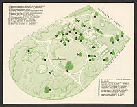
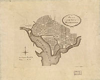
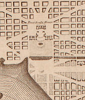
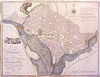
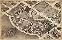
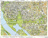
  • 1800 Map of L'Enfant Plan for Washington, D.C.
    John Reid
    map
    This map showing the plan for the city of Washington, D.C. was published by John Reid in 1800 and based upon the famous L'Enfant-Ellicott plan published by Thackara and Vallance in 1792. President George Washington asked French-born architect Pierre Charles L'Enfant to design the new capital. L'Enfant developed plans for the city, but his refusal to cooperate with the president’s commissioners led to his dismissal in February 1792. The Commissioners of the District of Columbia began implementation of the plan under the direction of surveyor Andrew Ellicott. Renewed interest in beautifying the nation's capital in the early 20th century, however, led to the revival of L'Enfant's vision, especially his plan for creating cardinal features in the city with the Capitol and White House connected by "by a grand avenue four hundred feet in breadth, and about a mile in length, bordered by gardens, ending in a slope from the houses on each side." This vista was the inspiration for McMillan Plan's park-like means of communication between the legislative and the executive branches which became the National Mall.
  • 1870 Map of the Ellipse (Parade)
    M. J. W.
    map
    White House
    This map shows the White House grounds as they existed in 1870 during President Ulysses S. Grant's administration. It is part of a series of maps drawn in 1935 showing the evolution of the buildings and pathways surrounding the White House. Over time the network of pathways grew and the buildings on either side of the White House expanded in size. The open space originally known as the "parade" became the oval-shaped space known today as the Ellipse. The map's artist is unknown aside from the initials "M.J.W." inscribed.
  • Correct Engraved map of the City of Washington
    William J. Stone
    map
    Washington, D.C.
    This engraved map of Washington, D.C. was created by William J. Stone in 1820. Stone includes an illustration of the White House, known at the time as the President's House, as it appeared during James Monroe's administration.
  • Plan of the City of Washington
    Pierre Charles L'Enfant
    map
    Washington, D.C.
    This map is the first printed edition of the plan of Washington designed by Pierre Charles L'Enfant. Andrew Ellicott created the engraved plate for the map with revisions for publication by mapmakers Thackara and Vallance of Philadelphia. President George Washington asked French-born architect L'Enfant to design the new capital. He developed plans for the city, but his refusal to cooperate with the president’s commissioners led to his dismissal in February 1792. The Commissioners of the District of Columbia began implementation of the plan under the direction of Ellicott. Renewed interest in beautifying the nation's capital in the early 20th century, however, led to the revival of L'Enfant's vision, especially his plan for creating cardinal features in the city with the Capitol and White House connected by "by a grand avenue four hundred feet in breadth, and about a mile in length, bordered by gardens, ending in a slope from the houses on each side." This vista was the inspiration for the 1902 McMillan Plan's park-like means of communication between the legislative and the executive branches which became the National Mall.
  • Isometrical View of the President's House
    Unknown
    map
    Washington, D.C.
    This 1857 map offers an isometrical, or angled, view of the White House grounds . The map anticipates the appearance of new, expanded government buildings, some never realized, and omits other landmarks such as the Andrew Jackson statue in Lafayette Park, which first appeared in the park in 1853.
  • Axonometric Map of Washington, D.C.
    Joseph Passonneau and Partners
    map
    President's Park
    Washington, D.C.
    This axonometric map of President's Park was created by Joseph Passonneau and Partners in 1996, during the William J. Clinton administration. The map shows the many 20th century additions to the park and the surrounding area, including the Department of Commerce building to the right of the Ellipse and the west end of the Federal Triangle complex just beyond the Commerce building. To the north of the White House, large office buildings loom over the historic Jackson Place row houses. A prominent Washington, D.C. architect, Passonneau worked on many of the city's urban planning and transportation projects.
  • 1851 Map of Ellipse (Parade)
    M. J. W.
    map
    drawings & plans
    This copy of an 1851 map shows the White House grounds as they existed during President Millard Fillmore's administration. It is part of a series of maps drawn in 1935 showing the evolution of the buildings and pathways surrounding the White House. Over time the network of pathways grew and the buildings on either side of the White House expanded in size. The circular area originally known as the "parade" became the oval-shaped space known today as the Ellipse. The map's artist is unknown aside from the initials "M.J.W." inscribed.
  • Survey of Virginia And Maryland
    Joshua Fry
    Peter Jefferson
    map
    Maryland
    Virginia
    Pennsylvania
    New Jersey
    Delaware
    drawings & plans
    This map of Virginia and Maryland was originally created by Joshua Fry and Peter Jefferson, father of Thomas Jefferson, and published by French map maker Robert de Vaugondy. In addition to the colonies of Virginia and Maryland, the map shows parts of Pennsylvania, New Jersey, and Delaware. To the west beyond the Allegheny Mountains lies the French territory of Louisiana, which at the time encompassed much of the western and northern portions of the North American continent.