• Map of the President's Square 1798
    Robert King
    map
    President's Park
    Washington, D.C.
    This map of President's Park and the surrounding buildings was drawn by government surveyor Robert King in 1798, during John Adams' administration. King depicts the position of federal buildings relative to the President's House, or White House, including the Treasury building to the east and an executive office building to the west. When John and Abigail Adams became the first occupants of the White House in 1800, construction to these buildings was ongoing.
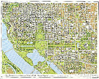
  • Axonometric Map of Washington, D.C.
    Joseph Passonneau and Partners
    map
    President's Park
    Washington, D.C.
    This axonometric map of President's Park was created by Joseph Passonneau and Partners in 1996, during the William J. Clinton administration. The map shows the many 20th century additions to the park and the surrounding area, including the Department of Commerce building to the right of the Ellipse and the west end of the Federal Triangle complex just beyond the Commerce building. To the north of the White House, large office buildings loom over the historic Jackson Place row houses. A prominent Washington, D.C. architect, Passonneau worked on many of the city's urban planning and transportation projects.