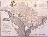
1800 Map of L'Enfant Plan for Washington, D.C., White House Collection
This map showing the plan for the city of Washington, D.C. was published by John Reid in 1800 and based upon the famous L'Enfant-Ellicott plan published by Thackara and Vallance in 1792. President George Washington asked French-born architect Pierre Charles L'Enfant to design the new capital. L'Enfant developed plans for the city, but his refusal to cooperate with the president’s commissioners led to his dismissal in February 1792. The Commissioners of the District of Columbia began implementation of the plan under the direction of surveyor Andrew Ellicott. Renewed interest in beautifying the nation's capital in the early 20th century, however, led to the revival of L'Enfant's vision, especially his plan for creating cardinal features in the city with the Capitol and White House connected by "by a grand avenue four hundred feet in breadth, and about a mile in length, bordered by gardens, ending in a slope from the houses on each side." This vista was the inspiration for McMillan Plan's park-like means of communication between the legislative and the executive branches which became the National Mall.
