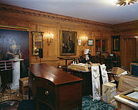
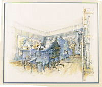
• Tricia Nixon Holds a Press Conference on Her Recent Engagement
    Jack E. Kightlinger
    wedding
    press
    Map Room
    Ground Floor
    First Family
    This photograph of Tricia Nixon answering questions from journalists about her engagement to Edward Cox was taken on March 17, 1971 by Jack E. Kightlinger. Tricia Nixon was the eldest daughter of President Richard M. Nixon and First Lady Pat Nixon. Her engagement and wedding garnered much attention from the media. The press conference took place in the Map Room, which is located on the Ground Floor of the Executive Mansion. It got its name when Franklin D. Roosevelt used the room to monitor and intake classified information during World War II. The room was the original Situation Room. Today the room acts as a sitting room but still displays maps in homage to its origins.
  • Tricia Nixon Holds a Press Conference on Her Recent Engagement
    Jack E. Kightlinger
    wedding
    press
    Map Room
    Ground Floor
    First Family
    This photograph of Tricia Nixon answering questions from journalists about her engagement to Edward Cox was taken on March 17, 1971 by Jack E. Kightlinger. Tricia Nixon was the eldest daughter of President Richard M. Nixon and First Lady Pat Nixon. Her engagement and wedding garnered much attention from the media. The press conference took place in the Map Room, which is located on the Ground Floor of the Executive Mansion. It got its name when Franklin D. Roosevelt used the room to monitor and intake classified information during World War II. The room was the original Situation Room. Today the room acts as a sitting room but still displays maps in homage to its origins.
  • President Reagan Poses for "Sports Illustrated" Cover
    Pete Souza
    Map Room
    Ground Floor
    sports
    White House Guests
    In this photograph, President Ronald Reagan poses with coach John Thompson and center Patrick Ewing of the Georgetown University men's basketball team. The trio were shot in the Map Room on the Ground Floor of the White House as part of a photo shoot for the cover of "Sports Illustrated" magazine by Pete Souza on November 11, 1984. The Georgetown Hoyas won the NCCA Division I Men's Championship the previous April. The Hoyas championship was the first for the university and made Thompson the first African-American head coach to lead his team to victory.
  • Temporary Curator's Office in the Map Room
    Robert L. Knudsen
    Map Room
    Ground Floor
    construction & maintenance
    This photograph of the Map Room was taken by Robert L. Knudsen on May 10,1962, during the John F. Kennedy administration. The room is seen here with pieces from the White House Collection acquired during First Lady Jacqueline Kennedy’s White House restoration project. The room served as the temporary location of the curator’s office, where new acquisitions were examined and cataloged before being displayed in rooms restored during the project. The Map Room is located on the Ground Floor of the Executive Mansion and got its name during the Franklin D. Roosevelt administration when President Roosevelt used the room to monitor and intake classified information during World War II. The room was the original Situation Room. Today the room acts as a sitting room but still displays maps in homage to its origins.
  • President Reagan Performs a Super Bowl Coin Toss
    Mary Anne Fackelman
    sports
    Map Room
    Ground Floor
    This photograph, taken by Mary Anne Fackelman on January 20, 1985, shows President Ronald Reagan tossing a coin at the start of Super Bowl XIX. President Reagan could not attend the final match between the Miami Dolphins and the San Francisco 49ers, as the game was scheduled for the same day as his second inauguration ceremony. Nonetheless, Reagan made sports history, as the first president to perform the coin toss for the Super Bowl. The coin toss was broadcast live from the Map Room of the White House.
  • Garden Tour Program, Carter Administration
    White House Calligraphy Office
    program
    South Grounds
    drawings & plans
    maps
    This is the unfolded internal page of a program created for a public White House gardens and grounds tour during the administration of President Jimmy Carter (1977-1981). The program includes a greeting from First Lady Rosalynn Carter, a map of the South Grounds including sites of presidential tree plantings, and information about the history of the gardens and their uses. Before the late-19th century, private citizens wandered the White House South Grounds like a public park, but by the Calvin Coolidge administration (1923-1929), the grounds were closed to the public due to security and privacy concerns. However, just as First Lady Jacqueline Kennedy opened the White House to the public with controlled public tours, in 1972 First Lady Pat Nixon established the tradition of hosting White House garden tours. During the anticipated event, which expanded to being held two weekends a year, lucky members of the public have a chance to view the first family's private gardens. To view the complete program, see 1127095. This program is part of a personal collection belonging to former White House Executive Chef Henry Haller. Haller served five first families and their distinguished guests as executive chef of the White House from 1966-1987.
  • Pat Nixon with Children from Washington Hospital
    Unknown
    Map Room
    Ground Floor
    visitors
    initiatives
    This photograph of First Lady Pat Nixon with Dorothy Anderson and Sean McCombs, patients at the Washington Hospital for Sick Children, was taken on October 21, 1971 during the administration of Richard M. Nixon. Mrs. Nixon had the first wheelchair ramps installed in the Executive Mansion for use by disabled or elderly visitors.
  • Map Room and Map Case, Nixon Administration
    Joseph H. Bailey
    Larry D. Kinney
    Map Room
    Ground Floor
    This photograph was taken in the Map Room on August 1973 during the administration of President Richard M. Nixon. A framed 1755 map of Maryland and Virginia by Joshua Fry and Peter Jefferson, father of President Thomas Jefferson, is ajar to reveal a hidden map case behind it. The Map Room is located on the Ground Floor of the Executive Mansion and got its name during the Franklin D. Roosevelt administration, when the space was used to monitor and intake classified information during World War II as a predecessor to the Situation Room. In 1970, First Lady Pat Nixon worked with curator Clement E. Conger to transform the Map Room from an office space to a sitting parlor, with maps adorning its wall in homage to its former use.
  • Map Room and Map Case, Nixon Administration
    Joseph H. Bailey
    Larry D. Kinney
    Map Room
    Ground Floor
    This photograph was taken in the Map Room on August 1973 during the administration of President Richard M. Nixon. The hanging is a 1755 map of Maryland and Virginia created by Joshua Fry and Peter Jefferson, father of President Thomas Jefferson. Behind the hanging wall map, a map case is concealed. The Map Room is located on the Ground Floor of the Executive Mansion and got its name during the Franklin D. Roosevelt administration, when the space was used to monitor and intake classified information during World War II as a predecessor to the Situation Room. In 1970, First Lady Pat Nixon worked with curator Clement E. Conger to transform the Map Room from an office space to a sitting parlor, with maps adorning its wall in homage to its former use.
  • Map Room and Map Case, Nixon Administration
    Joseph H. Bailey
    Larry D. Kinney
    Map Room
    Ground Floor
    This photograph was taken in the Map Room on August 1973 during the administration of President Richard M. Nixon. A framed 1755 map of Maryland and Virginia by Joshua Fry and Peter Jefferson, father of President Thomas Jefferson, is ajar to reveal a hidden map case behind it. The Map Room is located on the Ground Floor of the Executive Mansion and got its name during the Franklin D. Roosevelt administration, when the space was used to monitor and intake classified information during World War II as a predecessor to the Situation Room. In 1970, First Lady Pat Nixon worked with curator Clement E. Conger to transform the Map Room from an office space to a sitting parlor, with maps adorning its wall in homage to its former use.
  • Map Room and Map Case, Nixon Administration
    Joseph H. Bailey
    Larry D. Kinney
    Map Room
    Ground Floor
    This photograph was taken in the Map Room on August 1973 during the administration of President Richard M. Nixon. A framed 1755 map of Maryland and Virginia by Joshua Fry and Peter Jefferson, father of President Thomas Jefferson, is ajar to reveal a hidden map case behind it. The Map Room is located on the Ground Floor of the Executive Mansion and got its name during the Franklin D. Roosevelt administration, when the space was used to monitor and intake classified information during World War II as a predecessor to the Situation Room. In 1970, First Lady Pat Nixon worked with curator Clement E. Conger to transform the Map Room from an office space to a sitting parlor, with maps adorning its wall in homage to its former use.
  • President Obama with Advisors in the Map Room
    Pete Souza
    Map Room
    Second Floor
    This photograph is of President Barack Obama working on his address to the nation regarding Syria, in the Map Room of the White House, on September 10, 2013. Seated from right are: director of speechwriting Cody Keenan; Ben Rhodes, deputy national security advisor for strategic communications; senior advisor Dan Pfeiffer; director of speechwriting Jon Favreau; President Obama; and an unidentified man.
  • USGS Topographical Map
    U.S. Geological Survey
    maps
    This topographical map by the U.S. Geological Survey depicts the region of Maryland along the Potomac River where the stones for the White House were quarried. The prevailing quarry was at Seneca, located on the map just north of the word "River" at the 20' by 5' grid mark.
  • Virginia and Maryland as it is Planted and Inhabited This Present Year 1670
    Augustine Herrman
    maps
    This 1670 map of the middle reaches of the Potomac River gives the locations of what would be Aquia quarry, marked Brents on the map and the site of the new Federal City to the east, labeled "Turkey Buzzard Point.” The map has north oriented to the east features the creator's portrait in the lower right quadrant, and notes about the geography of important events that occurred at various locations.
  • Map of the Prince of Wales' North American Tour
    Unknown
    map
    This map depicts the route of Albert Edward, the Prince of Wales and the future King Edward VII of Great Britain, during his 1860 goodwill tour of Canada and United States. Initially his mother, Queen Victoria, intended the for Prince of Wales to visit Canada. After hearing of the prince's tour, President James Buchanan invited him to the White House and the trip was expanded to include the United States. The map showing his route was published in British novelist Marie Belloc Lowndes' biography of the Prince of Wales entitled "H. R. H., the Prince of Wales; an account of his career, including his birth, education, travels, marriage and home life; and philanthropic, social and political work."
  • Franklin D. Roosevelt in Map Room
    Unknown
    Map Room
    Ground Floor
    In this color drawing, President Franklin D. Roosevelt is depicted sitting at a desk in the Map Room of the White House. This drawing shows the President sitting in a wheelchair, but during the course of his presidency, he went to great lengths to not have the public see him using a wheelchair.
  • Laura Bush and Photographer Eric Draper in Map Room
    Susan Sterner
    Map Room
    This photograph by Susan Sterner shows First Lady Laura Bush and photographer Eric Draper in the Map Room. Draper is photographing President George W. Bush for his official portrait.
  • Plan of the City of Washington
    Pierre Charles L'Enfant
    map
    Washington, D.C.
    This map is the first printed edition of the plan of Washington designed by Pierre Charles L'Enfant. Andrew Ellicott created the engraved plate for the map with revisions for publication by mapmakers Thackara and Vallance of Philadelphia. President George Washington asked French-born architect L'Enfant to design the new capital. He developed plans for the city, but his refusal to cooperate with the president’s commissioners led to his dismissal in February 1792. The Commissioners of the District of Columbia began implementation of the plan under the direction of Ellicott. Renewed interest in beautifying the nation's capital in the early 20th century, however, led to the revival of L'Enfant's vision, especially his plan for creating cardinal features in the city with the Capitol and White House connected by "by a grand avenue four hundred feet in breadth, and about a mile in length, bordered by gardens, ending in a slope from the houses on each side." This vista was the inspiration for the 1902 McMillan Plan's park-like means of communication between the legislative and the executive branches which became the National Mall.
  • Map Room
    Erik Kvalsvik
    Map Room
    Ground Floor
    This undated photograph of the Map Room was taken by Erik Kvalsvik. The Map Room is located on the Ground Floor of the Executive Mansion and got its name during the Franklin D. Roosevelt administration, when President Roosevelt used the room to monitor and intake classified information during World War II. The room was the original Situation Room. Today the room acts as a sitting room but still displays maps in homage to its origins, as seen in this photograph of the southwest corner of the room.
  • Last World War II Situation Map
    Unknown
    Map
    This map was created in 1945 during the Franklin D. Roosevelt administration. The framed war map of Europe shows the movement of forces predicted for May 1, 1945 and was delivered to President Roosevelt during his respite in Warm Springs, Georgia in April 1945. It is likely the last map Roosevelt examined before his death on April 12th. The map was saved by Ensign George Elsey who worked in the Map Room, a room started by Roosevelt on the Ground Floor of the Executive Mansion to monitor movements and classified information during World War II. Today, the room is a sitting room, but the Map Room was a predecessor for the Situation Room.
  • Map Room, Barack Obama Administration
    Peter Vitale
    Map Room
    Ground Floor
    This photograph of the Map Room by Peter Vitale was 2010 during the Barack Obama administration. The Map Room is located on the Ground Floor of the Executive Mansion and got its name during the Franklin D. Roosevelt administration, when President Roosevelt used the room to monitor and intake classified information during World War II. The room was the original Situation Room. Today the room acts as a sitting room but still displays maps in homage to its origins, as seen in this photograph of the southwest corner of the room.
  • Map Room, Barack Obama Administration
    Bruce White
    Map Room
    Ground Floor
    This photograph of the Map Room by Bruce White was taken in 2010 during the Barack Obama administration. The Map Room is located on the Ground Floor of the Executive Mansion and got its name when Franklin D. Roosevelt used the room to monitor and intake classified information during World War II. The room was the original Situation Room. Today the room acts as a sitting room but still displays maps in homage to its origins, as seen in this photograph of the east wall of the room.
  • Map of the President's Square 1798
    Robert King
    map
    President's Park
    Washington, D.C.
    This map of President's Park and the surrounding buildings was drawn by government surveyor Robert King in 1798, during John Adams' administration. King depicts the position of federal buildings relative to the President's House, or White House, including the Treasury building to the east and an executive office building to the west. When John and Abigail Adams became the first occupants of the White House in 1800, construction to these buildings was ongoing.
  • 1792 Detail of the First Official Plan
    Pierre Charles L'Enfant
    map
    Washington, D.C.
    This detail of the President's House is from the first printed edition of the plan of Washington designed by Pierre Charles L'Enfant. Andrew Ellicott created the engraved plate for the map with revisions for publication by mapmakers Thackara and Vallance of Philadelphia. President George Washington asked French-born architect L'Enfant to design the new capital. He developed plans for the city, but his refusal to cooperate with the president’s commissioners led to his dismissal in February 1792. The Commissioners of the District of Columbia began implementation of the plan under the direction of Ellicott. Renewed interest in beautifying the nation's capital in the early 20th century, however, led to the revival of L'Enfant's vision, especially his plan for creating cardinal features in the city with the Capitol and White House connected by "by a grand avenue four hundred feet in breadth, and about a mile in length, bordered by gardens, ending in a slope from the houses on each side." This vista was the inspiration for the 1902 McMillan Plan's park-like means of communication between the legislative and the executive branches which became the National Mall.