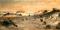
• Princeton Landscape
    Ellen Axson Wilson
    landscapes
    painting
    hobbies
    New Jersey
    This landscape painting of Princeton, New Jersey was done by Ellen Axson Wilson, President Woodrow Wilson's first wife. An accomplished artist, she had a studio set up in the third floor of the White House.
  • Boys Crabbing
    William Tylee Ranney
    painting
    New Jersey
    ships
    This painting of a group of boys is by William Ranney. The four boys are grouped together, almost mimicking the slope of the large, dark cloud behind them. On the left side of the canvas is a brighter sky with a lighthouse visible in the distance. Although Ranney, an American artist, is best known for western scenes, he also painted subjects near his New Jersey studio. This painting is one of his New Jersey-set paintings. An enthusiastic cricket player, he helped begin the New York Cricket Club, which played many of its games at the Elysian Fields in Hoboken, New Jersey.
  • Sand Dunes at Sunset, Atlantic City
    Henry Ossawa Tanner
    landscapes
    painting
    New Jersey
    This painting of a windy beach with rising, sandy dunes is by African-American landscape painter Henry Ossawa Tanner. It is the first painting by an African-American artist acquired for the White House Collection. The painting looks out from the beach towards the ocean, though only small waves cresting on the horizon and two far off sailboats are visible. The dunes and shore take up the majority of the canvas and Tanner actually mixed sand into his pigments to better capture the rough texture. Tanner, whose father was an African Methodist Episcopal Church minister and whose mother had been born into slavery and escaped, was born in Pennsylvania. In 1891 he moved to France to escape racism and the limitations imposed on his race in the United States.
  • Survey of Virginia And Maryland
    Joshua Fry
    Peter Jefferson
    map
    Maryland
    Virginia
    Pennsylvania
    New Jersey
    Delaware
    drawings & plans
    This map of Virginia and Maryland was originally created by Joshua Fry and Peter Jefferson, father of Thomas Jefferson, and published by French map maker Robert de Vaugondy. In addition to the colonies of Virginia and Maryland, the map shows parts of Pennsylvania, New Jersey, and Delaware. To the west beyond the Allegheny Mountains lies the French territory of Louisiana, which at the time encompassed much of the western and northern portions of the North American continent.